Applications of Unmanned Aerial Systems in Agricultural Operation Management: Part III: Best Practices for Efficient Aerial Surveying

Agricultural drone setup at a crop field. Photo taken 01-22-20.

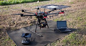
With the increasing use of unmanned aerial systems (UASs) in the agricultural domain, ensuring the consistency and completeness of aerial surveys is critical in order to establish repeatability and consistency in data collection activities. This publication covers five main steps to ensure that aerial data collections are repeatable and consistent among missions. It is one of a three-part series focusing on the applications, configuration, and best practices for using UASs in agricultural operations management. Written by Aditya Singh and James Fletcher, and published by the UF/IFAS Department of Agricultural and Biological Engineering, February 2021.
https://edis.ifas.ufl.edu/ae553

Applications of Unmanned Aerial Systems in Agricultural Operation Management: Part II: Platforms and Payloads

Agricultural drone setup at a crop field. Photo taken 01-22-20.

Unmanned aerial systems (UASs, UAVs, or drones) have emerged as an important tool for farmers, Extension agents, and landowners to map, monitor, and manage their properties. This 5-page publication provides an overview of the primary components of typical UASs to help growers, landowners, and/or Extension agents who want to configure and/or purchase a UAS or sensor system for agricultural operations. This document is one of a three-part series focusing on the applications, configuration, and best practices for using UASs in agricultural operations management. Written by Aditya Singh and James Fletcher, and published by the UF/IFAS Department of Agricultural and Biological Engineering, February 2021.
https://edis.ifas.ufl.edu/ae552